

Parliamentarians have been warned that bureaucracy and red tape are holding back the use of spray drones on agriculture – and that investment in the sector could unlock major benefits.
Harper Adams University Researcher, Jonathan Gill, gave the warning to a recent meeting of the All-party Parliamentary Group on Science and Technology in Agriculture – where he spoke to an audience of MPs and peers about some of the opportunities the use of spray drones could present, including reducing fossil fuel intensive farming – and increasing the transparency of food provenance.
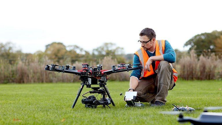
Drawing on the work which he has been doing at Harper Adams University’s Hands-Free Hectare, he explained how drones could be used to distribute plant protection products – and some of the current regulatory burdens which are holding back their use.
The operational height for these drones is a few metres above the ground and from the crops, therefore these drones operate at a height well below the treeline and will not come in to conflict with an aircraft in airspace.
Jonathan said: “Instead, the regulatory issues we are facing are with the Health and Safety Executive and Chemicals Regulation Division, and are more about the products the drones are distributing.
“Yet used correctly, an operator or farmer can know where, when, and how much chemical is distributed to an area – which allows the provenance of the food produced to become ever more transparent – while, importantly, reducing chemical use.
“Despite this being done in a much more targeted manner than some conventional delivery, there are still regulatory issues, both with the use of drones and with research. Drones, being fully electric, can also be charged by wind or solar – cutting the need for fossil fuels entirely and making significant reductions to the carbon footprint of any spraying – delivering further environmental benefits,” he argued.
During his presentation, Jonathan also re-iterated the need for investment in getting smart spray and drone systems to the point where they are authorised for use – with testing and efficiency confirmation at the top of his priority lists.
He added: “There were a number of interesting conversations following my presentation and I’m planning on keeping in touch with interested APPG members in the coming months.”
All-Party Group member, Viscount Ridley, who is leading a Regulatory Horizons Council investigation into better regulation of drone technology, welcomed Jonathan’s contribution to the session.
He said: “The use of drones in agriculture offers significant opportunities to improve the precision and efficiency of both crop and livestock production, from accurate field mapping and management of crop health issues to monitoring grazing livestock.
“The APPG session, including Jonathan Gill’s presentation on the bureaucratic hurdles he has encountered in trialling the use of spray drones, highlighted a number of areas where the UK’s ambition to be a global leader in precision agriculture does not appear to be matched by a proportionate regulatory approach.
“That information will be extremely valuable in identifying options for a more enabling regulatory environment to support the safe and effective use of drone technology in agriculture.”
Drones: A new age of farming at Cereals this week
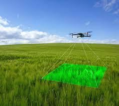
Drones are changing the face of farming, allowing for precision, optimisation, visualisation and application in ways that have never been seen before. This year’s Cereal’s Event held in Lincolnshire on Wednesday and Thursday of this week, showcased some of the latest developments.
Farmers have become familiar with using drones to map fields and identify issues with soils, yield variability and weeds, but the next revolution could be a game changer for a number of reasons.
The Cereals Drone Zone, themed 'Scout, seed and feed: Cover cropping with zero carbon' showed off ground-breaking drones and their capabilities, which could revolutionise some aspects of farming, said the organisers who hosted drone demonstrations twice daily.
Although various eastern countries are already using drones to spray crops, this technology is still in its infancy in Europe – largely due to regulations – but the British Drone Consortium is working to change this.
“The regulations mean people have been afraid of new technology, but in China and the East they have been happy to embrace it,” pointed out Jim Bishop, director at Red Air Media. “We have spent the past year working out a way to use drones for spraying and are at the point we just need chemical companies on board. We can do anything with a drone.”
Here’s a flavour of which companies and their drones featured at Cereals:
Drone Ag
Skippy Scout is Drone Ag’s crop scouting system and features a drone taking photos of key points in fields.
Able to scout 10ha in about five minutes, it can help identify weeds and damage to build field reports on crop health, problems and progress.
At Cereals, it demonstrated its automated flight mode as it collected close up leaf imagery at key points in the arena, before generating a crop report within a few minutes.
British Drone Consortium
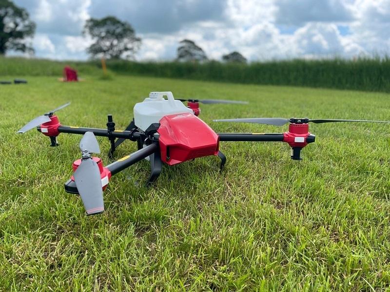
XAG’s JetSeed was seen in operation and it can spread seed, fertiliser and plant protection products.
The British Drone Consortium (BDC) – the only organisation with permission to fly this drone in the UK – can precisely propel seeds and fertiliser, via stable jets of air, to crops. It has an autonomous flight control system and high-accuracy navigation. Its on-board hopper can carry 15-20kg loads at present and can cover around 8-10ha per hour.
“One of the biggest issues in this country can be farmers not being able to get tractors onto fields in wet weather to sow seeds,” explained Mr Bishop. “Jetseed was designed for use in paddy fields and so is ideal for these conditions. Working with the government, we are aiming to be the first licenced drone organisation to sow seeds and apply sprays.”
The organisation is already working in Turkey to deploy chemicals and salts in the Black Sea to disperse sea 'snot' (water pollution caused by algal blooms) using the drone.
Working with other companies, fields can also be mapped and 3D images of crops created to tailor spot application. With the adoption of the technology, farmers will be able to contract in drones and pilots, or get trained up and licenced to use drones themselves through the BDC.
Harper Adams University
It brought the only V40 drone that's been seen outside of China to Cereals and its National Centre for Precision Farming demonstrated its capabilities.
The V40 is the first of a new generation of drones specifically designed to improve spraying performance. This draws on XAG’s decade of development and millions of hectares sprayed.
A key innovation is its double rotor design which brings numerous advantages. The first is that it improves spray penetration into the crop because the airflow below the drone is less turbulent than on older four, or eight rotor designs. A second advantage is the size and volume being reduced by two-thirds, makes it lighter and easier to transport.
Autospray Systems
Supplying both air and ground-based autonomous spray solutions, AutoSpray Systems had on demo the R150.
The ground-based set-up is a modular, multi-function platform which can spray crops, cut grass, sow seeds, spread pellets and tow up to a tonne. It has an electric drive train to minimise carbon footprint and noise pollution.
It also has an independent electric four-wheel-drive system and differential steering for manoeuvrability with a minimum turning diameter of 0.7m. Its 100-litre capacity intelligent spray tank has real-time sensing to enable fully autonomous operation and data integration.
Dual Engine RTK positioning gives cm-level navigational accuracy with fully automated route recording and repeatability. The R150-ATJ can operate in total darkness and is suitable for 24-hour operation.
Metos UK
A new range of in-field sensors from Metos showed growers a lower-cost means to get insight on field conditions and improve efficiencies in fungicide use and irrigation, potentially reducing costs.
The LoRAIN range included three models offering a range of measurements and these can be used in any combination – either individually, or as a network across multiple fields to give greater information over a wide area.
David Whattoff, from Metos UK, said: “With no annual subscription, low-cost LoRain sensors can be installed in every field for the season, moved each year, and provide information on key conditions to help farmers optimise their input spend.”
The entry-level ‘Rain’ model measures rainfall only, while the mid-range LoRAIN adds temperature and humidity sensors, allowing users to add a disease model which gives insight into disease risk based on previous climatic conditions.
“Where disease risk is low, growers can use this information to justify reduced fungicide applications or alter their choice of actives,” explained David. “Disease models are an add-on product, available for a wide variety of crops, including cereals, root crops, vegetables and fruit, and highlight high, medium and low risk periods for relevant diseases.”
The LoRAIN ‘Soil’ model added a soil moisture probe to rainfall, temperature and humidity sensors, further increasing the data available on field conditions – particularly useful in irrigated crops. This can provides insight on soil moisture deficit over time, so you can see the impact of rain or irrigation events, and adjust schedules or water volume as required.
“With erratic summer rainfall, and the increasing cost of water abstraction, saving money and time on irrigation will be vital for some growers,” said David. “For potato crops, blight forecasts are not always accurate at field level, so adding a potato disease model to the LoRAIN Soil provides greater assurance when reviewing spray programmes and choice of actives.”
These wireless sensors are simple to install, with a ‘plug and play’ design and can easily be removed or moved to new locations each season. They have a solar panel and long-life battery to provide power.
Data is measured and logged every 15 minutes, and transmitted to the app every hour, giving reliable and up to date information to help inform decision making.


Comments: Our rules
We want our comments to be a lively and valuable part of our community - a place where readers can debate and engage with the most important local issues. The ability to comment on our stories is a privilege, not a right, however, and that privilege may be withdrawn if it is abused or misused.
Please report any comments that break our rules.
Read the rules here